1
/
of
1
DJI
Zenmuse L2 (NA) SP Plus
Zenmuse L2 (NA) SP Plus
Regular price
$18,170.00 CAD
Regular price
Sale price
$18,170.00 CAD
Unit price
/
per
Shipping calculated at checkout.
Couldn't load pickup availability
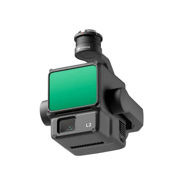
The Zenmuse L2 integrates advanced LiDAR, a high-accuracy IMU system, and a 4/3 CMOS RGB mapping camera to provide precise and reliable geospatial data acquisition for DJI flight platforms. When paired with DJI Terra, it offers a comprehensive solution for 3D data collection and high-accuracy post-processing, capable of scanning complex subjects over extended ranges and generating precise point cloud models. It achieves vertical accuracy of 4cm and horizontal accuracy of 5cm, collecting data from a 2.5km² area in a single flight. The L2 operates efficiently with the Matrice 350 RTK, enhancing operational safety and detecting small objects with high detail, even through dense vegetation.
| General | |
|---|---|
| Product Name | Zenmuse L2 |
| Power | 28 W (typical), 58 W (max.) |
| IP Rating | IP54 |
| Supported Aircraft | Matrice 300 RTK (requires DJI RC Plus), Matrice 350 RTK |
| Storage Temperature | -20°C to 60°C (-4°F to 140°F) |
| System Performance | |
| Detection Range | 450m at 50% reflectivity, 0 klx; 250m at 10% reflectivity, 100 klx |
| Point Cloud Rate | Single return: max. 240,000 pts/s; Multiple returns: max. 1,200,000 pts/s |
| System Accuracy | Horizontal: 5 cm at 150 m; Vertical: 4 cm at 150 m |
| Real-Time Point Cloud Coloring Coding | Reflectivity, Height, Distance, RGB |
| LiDAR | |
| Ranging Accuracy (RMS 1) | 2 cm at 150 m |
| Maximum Returns Supported | 5 |
| Scanning Modes | Non-repetitive scanning pattern, Repetitive scanning pattern |
| FOV | Repetitive scanning pattern: Horizontal 70°, Vertical 3°; Non-repetitive scanning pattern: Horizontal 70°, Vertical 75° |
| Minimum Detection Range | 3 m |
| Laser Beam Divergence | Horizontal 0.2 mrad, Vertical 0.6 mrad |
| Laser Wavelength | 905 nm |
| Laser Spot Size | Horizontal 4 cm, Vertical 12 cm at 100 m (FWHM) |
| Laser Pulse Emission Frequency | 240 kHz |
| Laser Safety | Class 1 (IEC 60825-1:2014) |
| Accessible Emission Limit (AEL) | 233.59 nJ |
| Reference Aperture | Effective Aperture: 23.85 mm (equivalent to circular) |
| Max Laser Pulse Emission Power Within 5 Nanoseconds | 46.718 W |
| Inertial Navigation System | |
| IMU Update Frequency | 200 Hz |
| Accelerometer Range | +/-6 g |
| Angular Velocity Meter Range | +/-300 dps |
| Yaw Accuracy (RMS 1 Sigma) | Real-time: 0.2°, Post-processing: 0.05° |
| Pitch/Roll Accuracy (RMS 1 Sigma) | Real-time: 0.05°, Post-processing: 0.025° |
| Horizontal Positioning Accuracy | RTK FIX: 1 cm + 1 ppm |
| Vertical Positioning Accuracy | RTK FIX: 1.5 cm + 1 ppm |
| RGB Mapping Camera | |
| Sensor | 4/3 CMOS, Effective Pixels: 20 MP |
| Lens | FOV: 84°, Format Equivalent: 24 mm, Aperture: f/2.8-f/11, Focus Points: 1 m to infinity (with autofocus) |
| Shutter Speed | Mechanical Shutter: 2-1/2000 s; Electronic Shutter: 2-1/8000 s |
| Shutter Count | 200000 |
| Photo Size | 5280x3956 (4:3) |
| Still Photography Modes | Single shot: 20 MP; Timed: 20 MP; JPEG Timed Interval: 0.7/1/2/3/5/7/10/15/20/30/60 s; RAW/JPEG + RAW Timed Interval: 2/3/5/7/10/15/20/30/60 s |
| Video Codec and Resolution | H.264; 4K: 3840x2160 at 30fps; FHD: 1920x1080 at 30fps |
| ISO | Video: 100-6400; Photo: 100-6400 |
| Video Bitrate | 4K: 85Mbps; FHD: 30 Mbps |
| Supported File System | exFAT |
| Photo Format | JPEG/DNG (RAW) |
| Video Format | MP4 (MPEG-4 AVC/H.264) |
| Gimbal | |
| Stabilization System | 3-axis (tilt, roll, pan) |
| Angular Vibration Range | 0.01° |
| Mounting | Detachable DJI SKYPORT |
| Mechanical Range | Tilt: -143° to +43°; Pan:+/-105° (Structural limit, not controllable range) |
| Controllable Range | Tilt: -120° to +30°; Pan: +/-90° |
| Operation Mode | Follow/Free/Re-center |
| Data Storage | |
| Raw Data Storage | Photo/IMU/Point cloud/GNSS/Calibration files |
| Point Cloud Data Storage | Real-time modeling data storage |
| Supported microSD Cards | microSD: Sequential writing speed 50 MB/s or above and UHS-I Speed Grade 3 rating or above; Max capacity: 256 GB. Use the recommended microSD cards. |
| Recommended microSD Cards | Lexar 1066x 64GB U3 A2 V30 microSDXC; Lexar 1066x 128GB U3 A2 V30 microSDXC; Kingston Canvas Go Plus 128GB U3 A2 V30 microSDXC; Lexar 1066x 256GB U3 A2 V30 microSDXC |
| Post-Processing | |
| Supported Software | DJI Terra |
| Data Format | DJI Terra supports exporting point cloud models in the following formats: PNTS/LAS/PLY/PCD/S3MB |
| Item Dimension (L"xW"xH") | 14 x 12 x 10 |
| Weight | 13 lbs |
| Warranty Information | 2 years |
Share